You have probably heard "El Niño" in every weather forecast for weeks now. NOAA issued an official El Niño advisory in 2026, and the pattern is expected to strengthen as the year goes on. But forecasters tend to explain it in jargon, so here is the plain-English version of what El Niño actually is, why 2026 is shaping up to be a significant one, and exactly what it means for your home and family. Once you understand the pattern, the right preparation becomes obvious. For the full action plan, start with how to prepare for El Niño 2026.
What El Niño actually is
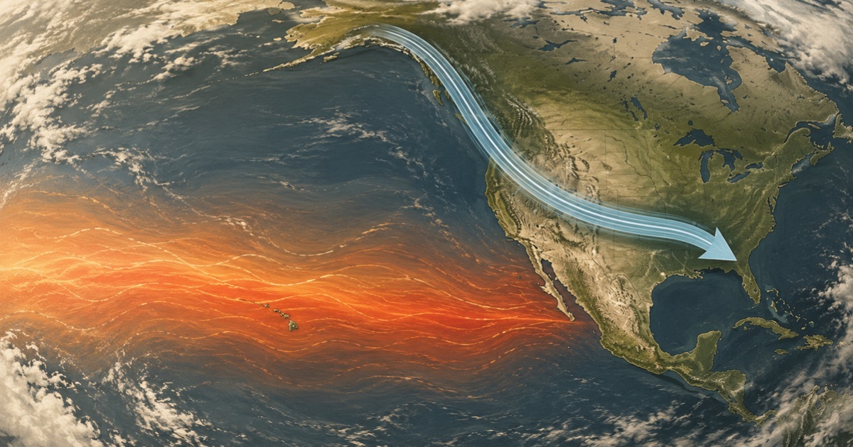
El Niño is a natural climate pattern centered in the Pacific Ocean. Normally, trade winds push warm surface water toward Asia, allowing cooler water to rise along the coast of South America. During an El Niño, those trade winds weaken or reverse, and a vast pool of warm water spreads across the central and eastern Pacific.
That warm water matters because it changes where heat and moisture rise into the atmosphere. And that, in turn, shifts the jet stream — the fast, high-altitude river of air that steers storm systems across North America. When the jet stream moves south, as it does during El Niño, the storm track moves with it. So an ocean temperature change thousands of miles away ends up deciding whether your winter is wet, dry, mild, or stormy.
Why 2026 is a notable El Niño
The 2026 pattern followed a common sequence: a weak La Niña — El Niño's cooler opposite — lingered into early winter, the Pacific relaxed to neutral conditions in spring, and then surface temperatures climbed into El Niño territory by mid-year. Forecasters now expect a moderate-to-strong event by the time it peaks.
That strength is the part worth paying attention to. Stronger El Niño winters historically deliver some of the wettest, stormiest conditions the southern United States ever sees, along with the flooding and power disruptions that come with them. A weak El Niño is a footnote; a moderate-to-strong one reshapes a whole season. That is why preparation is genuinely worth your time this year rather than a shrug.
How El Niño changes weather by region
This is the most important section, because El Niño is not one forecast — it is several, depending on where you live.
- Southern U.S. (California to Florida): Wetter and stormier. Expect more rain, a higher flood risk, and more frequent severe weather. This is the highest-impact zone, and flood preparation should be the priority.
- Pacific Northwest and northern Rockies: Often drier and milder than normal. The concern here flips to drought, low snowpack, and elevated wildfire risk heading into the following year.
- Ohio Valley and parts of the Midwest: Frequently drier as well, though storms can still punch through.
- Northern tier and Northeast: Typically milder winters overall, but individual storms — ice, heavy snow, wind — can still be severe and knock out power.
- Atlantic hurricane season: Usually suppressed. El Niño increases wind shear that tears apart developing storms, and NOAA forecasts a below-normal 2026 Atlantic season.
What this means for your prep
Match your effort to your region. If you are in the storm-and-flood belt, your top priorities are flood preparedness, how to flood-proof your home, and power outage prep, since saturated ground and high winds bring down power lines.
If you are in a drier zone, shift toward drought prep and serious water storage, and consider rainwater harvesting to bank whatever rain does fall. And everyone, in every region, benefits from a winter storm plan, because even milder winters produce the occasional dangerous storm.
No matter where you live, a battery or hand-crank noaa-radio is the one piece of gear that pays off in every scenario, because it keeps you ahead of fast-moving weather when the power and cell networks are down.
The advantage you have
Here is the encouraging truth: El Niño is forecastable months ahead. You are not reacting to a surprise — you are preparing for a known, scheduled risk. That lead time is a gift most disasters don't give you. Use it.
How forecasters actually measure El Niño
When meteorologists declare an El Niño, they're working from specific ocean measurements, not guesswork. The key metric is sea-surface temperature in a stretch of the central Pacific known as the Niño 3.4 region. When temperatures there run about 0.5°C above the long-term average and stay elevated, an El Niño is underway; the further above average and the longer it persists, the stronger the event. Forecasters track this with the Oceanic Niño Index, a rolling three-month average that smooths out short-term noise. This is why an El Niño advisory comes with confidence months ahead — the ocean signal builds slowly and visibly, giving scientists (and you) a reliable heads-up. When you hear "moderate-to-strong El Niño" for 2026, it means those Pacific temperatures are running well above normal and are expected to stay there through the peak season.
Frequently asked questions
How long will El Niño 2026 last?
El Niño conditions are expected to persist and strengthen through the end of 2026 and into the winter of 2026-27, then gradually weaken through the following spring. The highest-impact weather typically lands in the fall and winter months, which is your preparation deadline.
Is El Niño caused by climate change?
No — El Niño is a natural cycle that has occurred for thousands of years, long before modern climate change. However, scientists note that a warmer background climate can amplify the rainfall, heat, and storm impacts that ride along with each El Niño, potentially making the effects more extreme.
How is El Niño different from La Niña?
They are the two opposite phases of the same Pacific cycle, called ENSO. La Niña features cooler-than-average Pacific waters and tends to push the storm track north, often bringing drier winters to the south. El Niño features warmer waters and pushes the storm track south, generally bringing wetter, stormier conditions to the southern U.S.
Will El Niño definitely cause flooding where I live?
Not definitely — El Niño shifts the odds, it doesn't guarantee outcomes. It makes heavy rain and flooding more likely across the southern U.S., but local geography and individual storms still decide what actually happens at your address. That's why preparing based on your regional risk is smarter than assuming.
Can forecasters predict exactly how strong El Niño will get?
Not with perfect precision, but they forecast it well. By tracking Pacific Ocean temperatures and using climate models, scientists can project the likely strength and timing months ahead, which is why you get advance notice. The exact peak intensity firms up as the season progresses, but the overall picture — a moderate-to-strong 2026 event — is established early.
Does a strong El Niño guarantee a bad winter for me?
No. El Niño shifts the odds toward certain patterns by region, but it doesn't dictate any single storm or guarantee an outcome at your specific address. Local geography and individual weather systems still matter. Treat it as a strong reason to prepare based on your regional risk, not as a certainty.